


Page 13 - Offshore Well Construction
P. 13
CHAPTER 9
                                            Surveying and Directional Drilling
        Petroleum Extension-The University of Texas at Austin


           SURVEYING
           Why Survey?
           Accurate data about the position of a borehole is required in order to monitor and control where a borehole is and
           where it is going for the following reasons:
               •    To hit geological targets
               •    To provide a better definition of geological and reservoir data to allow for production optimization
               •    To avoid collision with other wells
               •    To define the target of a relief well for blowout contingency planning
               •    To provide accurate vertical depths for the purpose of well control
               •    To provide data for operational activities such as running and cementing casing
               •    To fulfill the requirements of local legislation

           Models of the Earth
                                                                  G
           The earth is commonly described as a spheri-
           cal object but it has a very irregular surface   P
           and carries mountain chains and deep-sea
           canyons in excess of 5 miles above and below                                        Earth's Surface
           mean sea level. The problem confronting
           surveyors is how to represent any point on                             L              Geoid Surface
           the earth’s surface on a flat sheet. Small areas
           of the earth may appear to have a flat surface                                         Spheroid Surface
           but, by and large, this is not the case. This has
           rendered it necessary to look more closely
           at the shape of the earth so that a method of
           representing this shape on a flat surface can                                               G'
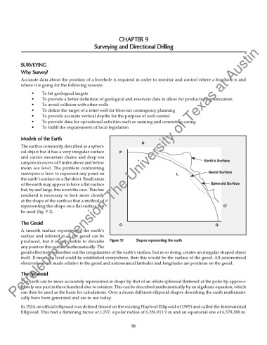
           be used (fig. 9.1).

           The Geoid                                    O                                           Q
           A smooth surface representing the earth’s
           surface and referred to as the geoid can be
           produced, but it is impossible to describe   Figure 9.1    Shapes representing the earth
           any point on this surface mathematically. The
           geoid effectively smoothes out the irregularities of the earth’s surface, but in so doing, creates an irregular shaped object
           itself. If mean sea level could be established everywhere, then this would be the surface of the geoid. All astronomical
           observations are made relative to the geoid and astronomical latitudes and longitudes are positions on the geoid.

           The Spheroid
           The earth can be more accurately represented in shape by that of an oblate spheroid flattened at the poles by approxi-
           mately one part in three hundred due to rotation. This can be described mathematically by an algebraic equation, which
           can then be used as the basis for calculations. Over a dozen different ellipsoid shapes describing the earth mathemati-
           cally have been generated and are in use today.

           In 1924, an official ellipsoid was defined (based on the existing Hayford Ellipsoid of 1909) and called the International
           Ellipsoid. This had a flattening factor of 1:297, a polar radius of 6,356,911.9 m and an equatorial one of 6,378,388 m.


                                                             9.1

